
Table of Contents
Summary
This page of the user manual provides an overview of the applications used by and supplied with Anchurus II and the IT Infrastructure you need to put in place in order to use it. You should use it as check list.
The choice of applications
The user manual page: Anchurus II supports the archaeological workflow shows that this system provides a lot of functionality. One of the design objectives of this system is that it is simple to learn and use. Anchurus II meets this objective by choosing a minimum number of applications and then providing explanations of how best to use them.
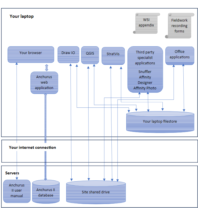
Figure 4.1 The Anchurus II applications and IT infrastructure
The Anchurus II applications
Figure 4.1 shows these applications in their operational settings. The Anchurus II web application runs off a server with the user interface being presented to you via your browser. All the other applications run on your laptop. The Anchurus II User manual is presented via the Anchurus web site which also runs on a server as is the site shared drive.
All the applications use data held in the site shared drive, however depending on the speed of your interface access you may want to hold copies of files in your laptop’s filestore.
Figure 4.1 shows the Anchurus II applications. From top left they are:
Your laptop
Anchurus II was built and tested using Windows laptops and has been used on Apple MACs. Some of the applications have been shown to work on other platforms but have not been comprehensively tested on them.
WSI appendix
This Word document holds an appendix which you add to your project proposal/Written Statement of Investigation (WSI). It explains how you are planning to use Anchurus II to support your work. For more details of how to access and use the user manual page Planning for your organisation to use Anchurus II.
Fieldwork recording forms
These are a series of PDF files each with a form that you will need to print and take on site so that your excavators can record what they find.
With Anchurus II we have adopted a policy that people working on site use paper forms to record the archaeology. We have done this because, as a voluntary sector organisation, your people are learning to be archaeologists and writing paper records makes for a better learning environment. It allows people to write drafts, make changes and it allows supervisors to review the written evidence and have conversations about what was and should have been written.
For more details see the user manual page: Working as a site leader
Your browser
With Anchurus II you use your browser to access the Anchurus II user manual and the Anchurus II web application. The system has been tested with the Microsoft Edge, Google Chrome and Firefox browsers and is known to work with other browsers such as Ecosia.
Draw IO
Draw IO is a drawing application which has been specialised so you can draw archaeological matrices.
Typically, during an excavation you draw and redraw stratigraphic matrices which record the contexts that you have identified, recorded and excavated.
During post excavation, you can draw additional Harris and other matrices which record your interpretation of the site.
Each matrix is held in a file stored on the site shared drive.
Draw IO is a third party application which you download from the Draw IO website.
QGIS
QGIS is a graphic information system that you use to record plans of the site, of anomalies found in the results of geophysics, Lidar and topographical surveys, of contexts, and of the position of section drawings and special finds.
Anchurus II separates these activities into two groups:
- Recording activities: which enables you to use the facilities in GQIS to geoposition and draw plan outlines and save them as shape files in folders on the site shared drive
- Browsing activities: which encourage you to view combinations of the shape files to help interpret the site
StratVis
This is an application which enables you to draw relative frequency and cumulative relative frequency charts which show the likelihood of finds with production dates falling in a given year per context or per group.
For example, when we find a sherd of pot in a context, and we know that that type of pot was produced at a distinct pottery which was active over a distinct time period, we can estimate the likelihood of that pot being produced in any given year during that period.
StratVis generalises this understanding by taking all the finds from a context or group and aggregating their estimates to create a stacked uniform distribution proportional to the inverse of the finds’ production duration and presenting the results in a graph which gives you an estimate of when the finds were deposited in that context or group. This together with details from the context’s stratigraphic matrix provides evidence of the date period when the context was being used.
StratVis is an application running in an Excel spreadsheet. To gain access to it, send us a message.
Third party specialist applications
The above components integrate with a range of third party applications chosen because they are widely used by the teams using Anchurus II and/or are freely available. These applications are:
- The drawing application: Affinity Designer
- The photograph processing package: Affinity Photo
- Geophysics data processing application: Snuffler
You can download these from their respective web sites.
Office applications
In Anchurus II, Office applications are an integral part of the system. You use them to produce reports, presentations and spreadsheets. The system has been built and tested using the Microsoft Office Suite.
The Anchurus II web application
This application enables large teams of people to access the Anchurus II database and ensures that the data they are inputting to the database meets defined integrity rules. As you input data using this application, it presents you with the relevant rules that it checks, thereby improving the quality of the data held in the database. The web application also provides queries so that, as you develop your interpretation of your archaeological site, you can check that the details held in the database support your interpretation.
Your laptop filestore
Providing you have an Internet fibre connection you can use Anchurus II by holding all your files in the site shared drive. However, for those with an Internet cable connection you may want to copy files from the shared drive into your laptop’s filestore.
If you do this and you change the copy on your laptop you must copy it back to the shared drive.
Your internet connection
Anchurus II uses your internet connection to gain access to the Anchurus II user manual, the Anchurus II database and your site shared drive.
If you have a fibre connection all will work well.
If you have cable connection then you will find that if there are a large number of concurrent users some of your application will not be able to connect to files on your site shared drive. As explained above, the only way forward is to copy files from the suite shared drive to your laptop filestore.
The Anchurus user manual
This is an integral part of the Anchurus system; it is presented on the Anchurus website.
The easiest way of finding this website is to type Anchurus into a search engine such as Google.
Anchurus II database
This database is used to hold and manipulate thekey data collected during the on-site work and all the additional data that is generated during post excavation.
Anchurus II is built on the fully functional MariaDB relational database management system. The benefits of using MariaDB are that it is free and that it supports the four core principles of atomicity, consistency, isolation, and durability (ACID) that ensure the reliability of database transactions.
Site shared drive
A site shared drive is a network drive which allows everybody involved in fieldwork on site and during post excavation to share data files. Typically this service is supported on either an organisations’ private server and network or it is provided by a third party network service. There are many such systems readily available, they include product offerings such as Google Drive, Dropbox, etc.
Ideally, a site shared drive should hold all the files that record and interpret the archaeological fieldwork. On that site, key features of such a drive are that it allows you to create a wide ranging structure of folders and the ability to manage who in your team can access what in that folder structure.
The Anchurus contribution to helping you create a site shared drive is to provide a comprehensive structure of folders that will enable you to store all the digital data created during fieldwork on a site.
Andrew Hutt, Tony Bakker and Susanne Earl
Version: v04
14/8/2026